

1
HUME AND HOVELL TRACK GEOPDF - MAP 5
- Camping
- Hiking
Free
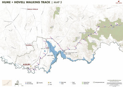
The Hume and Hovell Track is a 426km track stretching across south-eastern New South Wales from Yass to Albury. Hikers can use this map to plan a walk, calculate distances between campsites and towns, and navigate along the track. There are five maps covering the entire length of the Hume and Hov...
Geographic area:
Category:
Trails
Size:
38.04MB
Publication:
April 2022
Language:
English
Map bounds
Check nearby maps Customer Reviews
2.0 Based on 1 Reviews
Write a Review Ask a Question - Reviews
- Questions
Filter Reviews:
01/16/2023
Anonymous
I recommend this product
Hume and Hovell
The Albury city section of the H & T track is sign posted well in places and poorly/not at all in others. Unfortunately the Avenza map is not a lot of help in an urban environment.
What you get with Avenza Maps

Reliable mapping tools
Record GPS tracks, add placemarks, add photos, measure distances, and much more.

Locate yourself with GPS
Avenza Maps offline GPS app on your mobile device can locate you on any map, without WiFi or network connectivity.

The best maps by the best publishers
Download professionally curated digital maps on the Avenza Map Store from the best-renowned publishers.